
Baïse map
The source is Capvern and the mouth is Garonne.
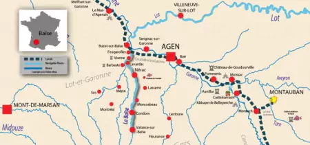
Navigation on the Baïse starts at Valence-sur-Baïse and ends at Saint-Léger.
The Baïse is 188.00 kilometres long (116.82 miles) with a total of 65.00 kilometres of navigable waterway.
There is a total of 21 locks, with an average of 1 lock every 3.1 kilometres (1.92 miles).
The highest point on the Baïse is 653.00 metres (2142′ 5″ ft) above sea level and the lowest point is at 30.00 metres (98′ 5″ ft) above sea level.
From Valence-sur-Baïse to Saint-Léger
The water draft is 1.20 metres (3′ 11″ ft) and the air draft is 3.50 metres (11′ 6″ ft).
General lock size
There are "Small" lock types.
Lock length 28.00 metres (91′ 10″ ft)
Lock width 4.30 metres (14′ 1″ ft)
Saint-Léger lock to the Garonne
There are "Freycinet-like" lock types.
Lock length 40.50 metres (132′ 10″ ft)
Lock width 5.20 metres (17′ 1″ ft)
Taking its source in the Lannemezan plateau in the Pyrenean Mountains, the Baïse throws itself into the Garonne river 187 kilometres farther north. The river has a long history of navigation and played a key role in the prosperity of many local villages and towns, including Condom and Nérac. It also has close ties to the d’Albret family, who owned some of the river's land, including Nérac. There are traces of the development of the river by Count Arnaud d’Albret, who was a medieval lord vassal of the king of England before swearing fealty to the French king in the early 1360s. The d’Albret family were smart administrators who increased their wealth with trade caravans in their lands in Gascogne. The family’s social standing drastically improved during the following two centuries, and they became kings of Navarre, a kingdom mostly located in Spain (the Basque country) and with land in actual France. In 1589, Prince Henri de Navarre became Henri IV, King of France. While Nérac and its surroundings, including segments of the Baïse, profited immensely from the presence of the Navarre monarchs, the departure of King Henri for Paris triggered a slight decline.
But, the port of Nérac was already developed, opening the city to new and more significant trading opportunities from the Baïse to the Garonne and then onwards to other waterways. Nérac remained an important regional city. In the 19th century, navigation on the river improved upstream to Condom. Until the 1950s, commercial barges transported many different goods from and to the towns on the Baïse River: cereal, sand, wine, and wood, among others. Commercial traffic has declined slowly, but it was enough to stop navigation in the 1950s. However, the river offered a wonderful setting for leisure navigation, and tourism took over.
Today, the Baïse has 65 kilometres of navigable water, from Valence-sur-Baïse to Saint-Léger, near the mouth of the Garonne. Not only can the river boast of flowing through beautiful landscapes, but some of the villages and cities are also must-sees. Buzet-sur-Baïse, where the river and the Garonne lateral canal flow, has a beautiful leisure port. From there, the canal runs parallel to the river for a few kilometres, going to Feugarolles, where the river goes under a bridge carrying the canal. Although Nérac has much more to offer, this city is a unique occasion to follow the footsteps of the kings of Navarre, including Henri IV and his wife, Queen Margot, popularised by Alexandre Dumas. To the South lies Condom, a town that has inspired many artists through the ages thanks to the nature surrounding it and its architectural heritage.
References
Self-drive boats cruising on the Baïse
| Fleet | Cruise route | |
|---|---|---|
| Locaboat by Riverly | Aquitaine | View the Locaboat by Riverly boats |
| Nicols by Riverly | Aquitaine | View the Nicols by Riverly boats |
| Le Boat | Aquitaine | View the Le Boat boats |
More details about The Aquitaine & Bordeaux region