
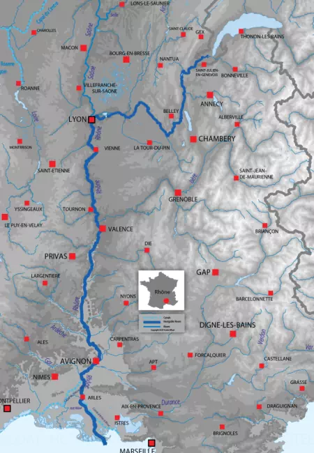
Rhône map
The source is Gletsch, Obergoms (Switzerland) and the mouth is Mediterranean Sea.
Navigation on the Rhône starts at Sault-Brénaz and ends at Saintes-Maries-de-la-Mer.
The Rhône is 812.00 kilometres long (504.55 miles) with a total of 469.00 kilometres of navigable waterway.
There is a total of 17 locks, with an average of 1 lock every 27.59 kilometres (17.14 miles).
The highest point on the Rhône is 2209.00 metres (1,372.61 miles) above sea level and the lowest point is at 0.00 metres (0′ 0″ ft) above sea level.
We've divided the Rhône into the following sections.
From Sault-Brénaz to Seyssel
The water draft is 2.00 metres (6′ 7″ ft) and the air draft is 6.00 metres (19′ 8″ ft).
There is a total of 4 locks in this section.
General lock size
There are "Freycinet" lock types.
Lock length 39.00 metres (127′ 11″ ft)
Lock width 5.20 metres (17′ 1″ ft)
From Lyon to Arles
The water draft is 3.00 metres (9′ 10″ ft) and the air draft is 6.30 metres (20′ 8″ ft).
There is a total of 12 locks in this section.
General lock size
There are "Large" lock types.
Lock length 190.00 metres (623′ 4″ ft)
Lock width 11.40 metres (37′ 5″ ft)
From Arles to Port-Saint-Louis
The water draft is 3.20 metres (10′ 6″ ft) and the air draft is 7.00 metres (22′ 12″ ft).
There is one lock in this section.
General lock size
There are "Large" lock types.
Lock length 135.00 metres (442′ 11″ ft)
Lock width 19.00 metres (62′ 4″ ft)
From Fourques to Saintes-Maries-de-la-Mer
The water draft is 1.00 metres (3′ 3″ ft) and the air draft is 3.00 metres (9′ 10″ ft).
From the Mediterranean Sea to Central France, the Rhone River and its basin have been important since before the Roman occupation of Gaul. Through the river, the Mediterranean Sea is naturally connected to the Loire, the Rhine, the Seine, and the Saone rivers. Men have also developed the river and its connections to other waterways. In the 19th century, the Rhone-Sète Canal improved the network of the Rhone by creating a junction with the Aquitaine waterways like the Midi Canal and the Garonne. Thus, the Rhone is a crossroad, key to European and Mediterranean commerce. The Romans wrote that great ships transported goods to and from the Mediterranean. The river has been essential to the regions it crosses. Lyon was built on the banks of the Rhone on purpose and its location helped the city become an important trading centre. Historians noted the diversity of goods transiting on the river in the 15th century: iron, salt, silk, cereals, diverse species of fish, including the prized anchovies, and wide varieties of fruits and vegetables depending on the seasons. If commercial traffic was already considerable from the Ancient Era to the early 19th century, navigation was difficult because of the unstable and hazardous rivers.
The Rhone has an infamous historical record of massive floods, with those of 1840, 1853, and 2003 considered among the most destructive. In 1823, the Rhône welcomed its first steamboat, inaugurating a new era of faster, easier navigation. However, except for small and independent improvements made by local populations living near and off the river, the Rhone had not undergone any major work of development or canalisation. This changed by the end of the 19th century.
Upstream of Lyon, the Upper Rhône is only partially canalised and developed for leisure navigation. In 1894, an 18-kilometre-long canal was built between Vaulx-en-Velin and Jons (northeast of Lyon). Known as the Canal de Jonage, it was constructed to ensure a water supply to the Cusset hydroelectric power plant. They both opened in 1899. Further upstream, the Rhone is composed of small isolated sections, rendering leisure cruising impractical. However, navigation is possible on the 80 kilometres separating Brégnier-Cordon, in the Ain department, and Seyssel in Savoy. There, the river cuts into a green and mountainous landscape, announcing its proximity to the Alps. At Chanaz, there is a junction with the little Savières canal, which leads to Lake Bourget, France's deepest and largest natural lake. The village of Seyssel is equipped to welcome leisure boats. Seyssel is known for the Sisselande type of barge, built purposely for navigation on the Rhone from the Middle Ages to the early 20th century.
The 310 kilometres from the confluence with the Saône in Lyon to the Mediterranean Sea are fully navigable. There were many discussions and small works during the 19th century, but the proper development and extensive canalisation of the Rhone began in the 1930s under the supervision of the Rhone National Company. Several small lateral and derivation canals allow safe and pleasant navigation where the river is otherwise difficult to tame. One of them, known as the Donzère-Mondragon canal, enables crossing a dam of the same name. Located in Bollène, this canal has a 23-metre-deep lock, the deepest in the country.
As the river makes its way towards the coast from Lyon, it crosses a wide variety of landscapes and beautiful cities and towns. Valence, in the Drôme department, has a rich cultural heritage. Founded over 2,000 years ago, the city boasts many churches, museums, and private mansions. After a tiring day of visiting the old city centre, Valence offers many local specialities inherited from centuries of traditions that will please everyone: wines, the unique Drôme raviole and caillette, and truffles.
Further South, in the heart of the Rhone Valley, the river reaches Montélimar. A small city, Montélimar has no less than a dozen listed monuments and many more sights and buildings of interest, from the 12th-century Adhémar castle to the European Museum of Fighter Aircrafts. Foodies will love knowing they are in the French capital of the Nougat confection. Avignon stands on the path of the Rhone as the sea gets closer and closer. Once the seat of the Avignon Papacy during the 14th century, it is one of the most beautiful French cities. Its historic centre comprises a cathedral, the old Papal Palace, a famous half-bridge and the entirety of the old city walls. No wonder Avignon is listed as a UNESCO World Heritage Site!
As the river flows through the Camargue Natural Park, it reaches Fourques and Arles, two cities that are next to each other. This is where the Rhône splits into two branches. The main one continues its way towards the Mediterranean Sea. At the beginning of the Rhone delta, Arles is well worth a visit. Nicknamed “the little Rome of Gaul”, it was once a great commercial and then a religious centre. Of its numerous monuments, the Arena has become a symbol of Arles’ rich cultural heritage. The second branch, called the Petit Rhône, runs through the West Camargue before reaching the sea at Les Saintes-Maries. Covering over 900 square kilometres, this natural park is renowned for its beauty and rich fauna and flora. There are more than 400 species of birds living in the Camargue, including hawks and pink flamingos. This is also where the only “cowboys” of Europe live, as they train the indigenous breed of white horses and watch over the black Camargue bulls.
Take a look at the city of Lyon through the camera lens of Anne-Sophie Clémençon, Anne-Sophie is an architectural historian and photographer.
References
- Aubert, Jean (1939), « Historique de la navigation sur le Haut-Rhône français » in Géocarrefour, n°15, pp. 181-90.
- Denel, F. (1970), « La navigation sur le Rhône au XVe siècle d’après les registres de péage de Baix », in Annales du Midi, n°82-98, pp. 287-299.
- Kirchner, Robert (1947), « Le Rhône voie navigable » in Géocarrefour, n°22, pp. 151-54.
- Provansal, Mireille, et al. (1999), « Le régime du Rhône dans l’Antiquité et au Haut Moyen Âge », in Gallia, n°56, p. 13-32.
- (s.d.), « Rivière Rhône » in Projet Babel [Online]
Barges cruising on the Rhône
| Name | Itinerary | Passengers | |
|---|---|---|---|
| Grand Victoria | Provence: Avignon - Frontignan | 6 | View the itinerary |